More Monsoon Driving
I’ve gotten several inquires since my last post about the roads we traveled. So I thought it a good idea to post a map for all to see. Basically our routes north followed the western New Mexico and Eastern Arizona borders. North of Interstate 10, Hwy 180 in New Mexico heads towards Interstate 40 or the old Route 66 while Hwy 191 hugs the eastern Arizona border. I doubt you’ll be able to make out much detail from the map, but I thought it would give a general idea.
Basically those two roads take us north towards Grants, NM which is situated between Acoma and Laguna Pueblos. If we’re going to Santa Clara Pueblo we continue north, otherwise we can head back south. Once we are south of Interstate 10 the options are several, one can follow Hwy 80 to the Mexican border or head up and over the Chiricahua mountains going from the Portal/Cave Creek area through Rustler Park and down the other side to Hwy 191 that leads to assorted Ghost Towns or historical places such as Tombstone and Bisbee.
That’s a very brief and short description and since most people reading this blog won’t ever travel those roads, it’s probably good enough. Those that will, more than likely live in this area and already know about them. So I’ll consider that done for now.

However, I figured if I went to the trouble to post this I couldn’t let it go with just a map especially one you really can’t read. So I thought why not throw up some of the buildings that have caught our attention along the way. They’re a mix that will tell you a lot about the history of the area, some more than others, some are just fun and couple of others will tell you about the Now. They’re not in the same class with the clouds in the previous post, but they’re fun.

This photo doesn’t really fit this collection but I came upon it while searching for the others below. It’s Athena’s sister Roxanne’s adobe house in Santa Clara Pueblo, NM. Once a barren piece of windswept land, it is now almost more vegetation than house due to efforts of her Flowering Tree Permaculture Institute.

These adobe wall ruins are in the old mining town of Gleeson, Arizona, the site of a small copper mine where Mexicans, who were not permitted to work in the larger mine at Bisbee, were allowed to work here. It’s always marvelous to watch the old adobes dissolve back into the earth.


The old store/saloon at Gleeson with current day mailboxes.

Small old adobe with simple porch for street viewing and conversation. Reserve, New Mexico.

This one is for my nieces and nephews, none other than Uncle Bill’s Bar in Reserve, New Mexico.
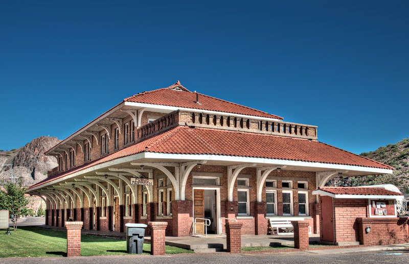
The old train station in Clifton, Arizona near one of the worlds’ largest copper mines. Completed in 1913.

Can’t show photos from southeastern Arizona without including Tombstone, once home to the infamous Wyatt Earp and Doc Holiday. Marie’s Bed and Breakfast in an old adobe.

Obviously not a building, but we found this great prickly pear cactus loaded with fruit on one of the Tombstone streets.

Metal clad building – Tombstone, AZ.

The old San Jose Lodging House – Tombstone, AZ.

Old wood two story Tombstone building.

Exquisite stone visitor’s center at the Chiricahua National Monument, AZ.

Great post Bill! Will you email a copy of "Uncle Bill's Bar" to me? I think my very own uncle Bill would get a kick out of it!
Thanks for keeping us updated on the adventures of your clan!
Jill Martinez
Sure thing, will do.
You article definitely has all the information and facts I needed about this subject. I didn’t know who to ask, so thank you kindly…